Urban GIS Project

Quick Links:
- Introduction: The Oldman River Region Urban GIS Project
- Benefits of the Urban GIS Project
- Project History
- Future Directions
- GIS Team
Intermunicipal Cooperation in Southern Alberta:
The Oldman River Region Urban GIS Project
Oldman River Regional Services Commission plays a key role in helping small communities in Southern Alberta benefit from a cooperative Geographic Information System (GIS) that allows the municipalities to make better and quicker decisions.
A GIS is the integration of geographical, or spatial, data that allows for easy understanding and access. A GIS can greatly simplify and streamline geographical information at say, a town office, where otherwise required information can be scattered in a variety of digital files, index cards, rolled up paper or maps on the wall. Specialized software, such as Autodesk Infrastructure Map Server, allows end users to view on their desktop via the internet spatial data such as cadastral, title and infrastructure mapping as well as multitude of database information such as infrastructure attributes, parcel ownership, tax roll data and land use districts. GIS allows users to synthesize the data and note trends or relationships.
The Oldman River Region Urban GIS Project is an outstanding example of intermunicipal cooperation which has produced a valuable information resource for all those involved. The project is a partnership between the Oldman River Regional Services Commission (ORRSC), a municipal cooperative planning organization, and 42 participating municipalities:
|
|
|
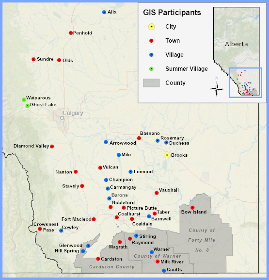
Through intermunicipal cooperation, these partners have worked together over the past eight years to create a centralized regional Geographic Information System (GIS). The project was designed to make it economically feasible for small communities to have access to GIS technology by sharing resources and expertise. GIS infrastructure and staff are centralized at the ORRSC office in Lethbridge and the Internet is used as a tool to deliver the information to individual municipalities in a password protected environment. The municipal partners and planning staff at ORRSC benefit from immediate access to information for decision-making, land use planning and infrastructure management. The partners of the Oldman River Region Urban GIS Project were proud to receive an Honorable Mention for Partnership at the 2004 Minister’s Awards for Municipal Excellence!
Benefits of the Urban GIS Project
The development of quality partnerships has been essential to the successful implementation of the Oldman River Region Urban GIS Project. This project has reduced duplication of data between different organizations and has made access to GIS economically feasible for the partnering municipalities. Data is stored on a central server located in Lethbridge and each community is able to access the GIS software and information via the Internet. ORRSC has assumed the role of service provider by managing the system and providing GIS expertise to the partnering municipalities. ORRSC staff has been actively involved in training municipal staff to use the GIS so that they are able to access information with ease. Partnering municipalities have begun to experience improved local management and operational efficiencies because of Internet access to accurate and up-to-date information. Other benefits of the urban GIS project include:
- Partnerships
- Cost savings through shared infrastructure and expertise in a central location
- Improved intermunicipal cooperation in the preparation of intermunicipal development plans, water quality studies and joint disaster plans
- Increased potential for future partnerships between municipalities
- Municipal Management
- Organized information that is updated, maintained and available on the Internet
- Access to an excellent planning tool that is useful in the preparation of reports and presentations for council meetings and public hearings
- Increased professional development as municipal staff explore the possibilities of the system
- Infrastructure Management
- Increased understanding of infrastructure deficiencies
- Reduced duplication of work
- Useful for providing notice to residents with regards to street and alley closures
- Assists in developing maintenance agreements with private sector developers
Project History
The impetus for the GIS project emerged out of the realization that urban members would benefit from GIS technology, but most communities within the region would not be able to afford a system on their own. ORRSC staff contacted all member and several non-member municipalities in southern Alberta in order to gauge interest and gained enough initial support to go ahead. The project received a Municipal Affairs’ 2000 Intermunicipal Sponsorship Grant. The entire program was approved as a multi-year pilot project in October of 2002 and was divided into three one-year phases: land Use, infrastructure and orthophotography (distortion-corrected aerial photography that can be used to accurately measure distance, for example).
The project has grown from serving a population of 36,219 in 18 municipalities to presently serving 112,921 in 42 municipalities. The GIS project is overseen by an advisory committee that meets a minimum of once annually. New initiatives or GIS news in general is conveyed to the membership via a GIS newsletter.
Phase I – 2002 to 2003
- Cadastral mapping, title mapping, land use district information and tax role databases were acquired for each municipality
- Web files were created to provide municipal users with access to GIS data stored at the ORRSC office in Lethbridge
- ORRSC staff traveled to municipal offices to load the viewer software and provide training
- ORRSC staff traveled to municipal offices to load the viewer software and provide training
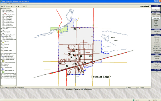
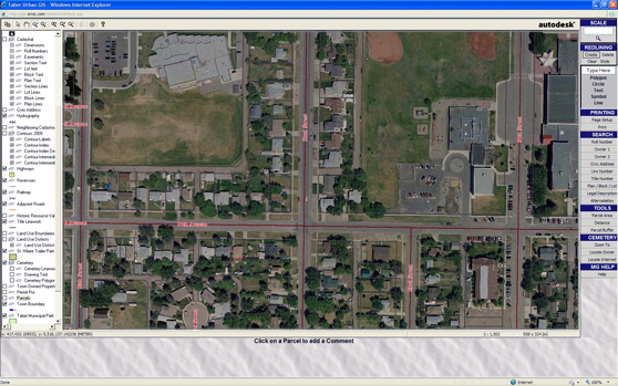
Phase I – Screenshot of Taber Urban GIS Overview
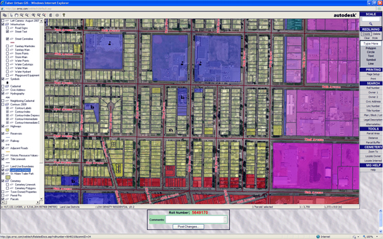
Phase I – Screenshot of Taber Land Use Districts
Phase II – 2004
- Information on road, water, sanitary sewer and storm sewer infrastructure networks was collected during 2004
- A GIS Advisory Committee was formed in order to ensure that the direction of the project would continue to meet the needs of the partners involved
- The municipalities received an Honourable Mention for Partnership at the Minister’s Awards for Municipal Excellence
- The Town of Raymond and the Village of Stirling joined the Urban GIS Project, bringing the total of number of participating partners to 21
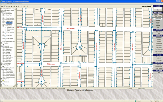
Phase II – Screenshot of Taber Urban GIS Water Infrastructure
Phase III – 2005
- New aerial photography was flown and a color orthophoto of each municipality was integrated into the GIS
- The total number of municipal partners rose to 25 when the Villages of Arrowwood and Milo and the Towns of Granum and High River joined the project
Phase III – Screenshot of Taber Urban GIS Orthophoto
The following are progress reports of the first 3 years of the project as well as the final report submitted to Alberta Municipal Affairs.
In retrospect, the Oldman River Region Urban GIS Project has met and exceeded the expectations of the project team. Partnering municipalities have continually increased their use of the system and several municipalities have joined the project since its inception. Late in 2005, the partnering municipalities received another grant, the Layer Enhancement Grant, from Municipal Affairs’ Sponsorship Program and these funds were used to develop four additional layers for the GIS project in 2006. An assessment layer, cemetery layer and registered plan layer have been added to the system.
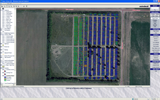
Layer Enhancement Grant – Screenshot of Taber Urban GIS Cemetery
Future Directions
The project continues to evolve with new layers and updates due to ever changing demand of its members and advances in GIS software and hardware. Below is a screenshot of the current GIS viewer which can be used with any operating system including mobile platforms such as iPhone and Android based smart phones and devices. It also comes with integrated Google Street View and many other new tools such as Map Themer, Query Builder and Edit Forms.
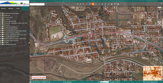
Current GIS Viewer
The GIS project team consists of the following people:
| Carlin Groves | CAD/GIS Technologist | (carlingroves@orrsc.com) |
| Mladen Kristic, C.E.T. | CAD/GIS Technologist | (mkristic@orrsc.com) |
| Kaylee Sailer | CAD/GIS Technologist | (kayleesailer@orrsc.com) |
| Jaime Thomas, GISP | GIS Analyst | (jaimethomas@orrsc.com) |
| Jordan Thomas | GIS Analyst | (jordanthomas@orrsc.com) |